
Mount Rogers/Grayson Highlands Loop Backpacking Guide
/
This article may contain affiliate links.
The Mount Rogers/Grayson Highlands loop hike is an iconic section of the Appalachian Trail, located in the southwestern hills of Virginia within the Jefferson National Forest. It also crosses over into the bordering Grayson Highlands State Park. The region was once home to early settlers in the late 1800s and early 1900s. Many areas are named after these settlers. Massie Gap takes its name from Lee Massey, who lived in the gap with his family. The Wilburn Ridge is named after the famed bear and wolf hunter Wilburn Waters.
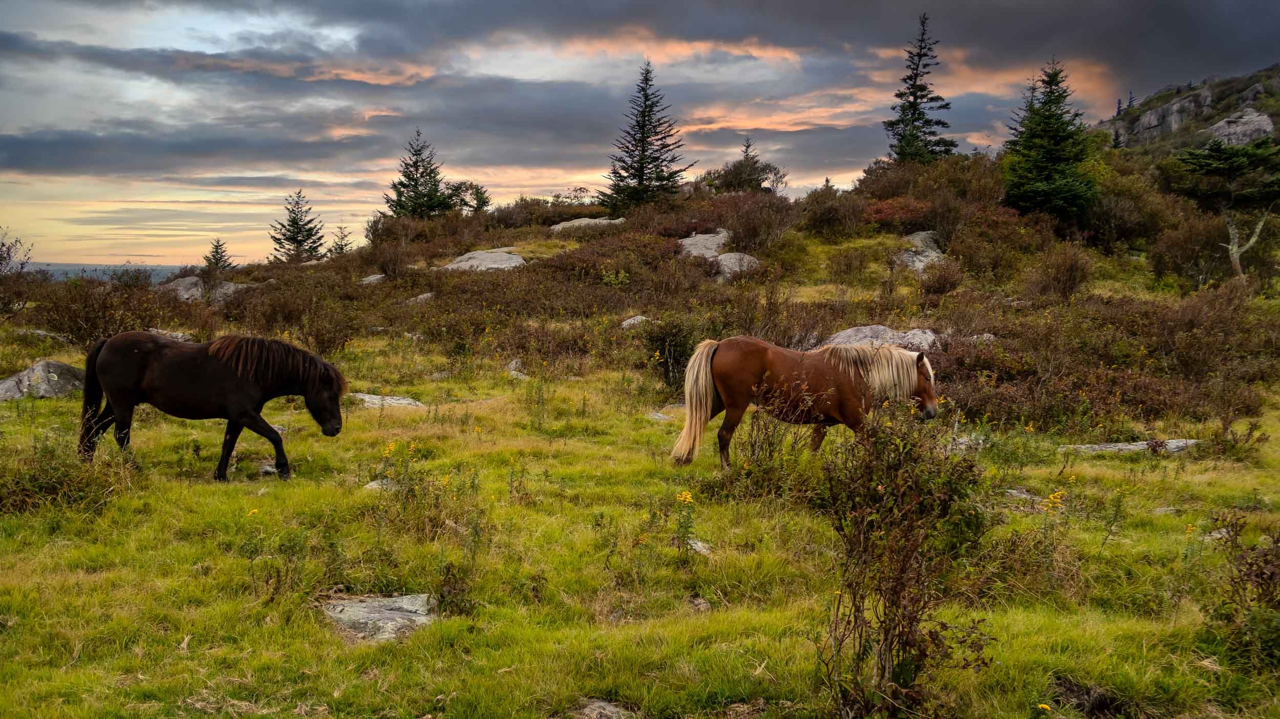
Today this region is best known for its vast mountain views and alpine peaks with wild ponies roaming about. This area is also home to Virginia's highest point, Mount Rogers, sitting at 5,729'. Additionally, there are many rock outcroppings on the trail that you can enjoy hiking through. This is a premier east-coast backpacking destination. With so many different things to see and experience, going on a trip like this will no doubt be a memorable one.
Trail Facts
Length: 21.1 Miles
Duration: 2-3 Days
Elevation Gain: 3,898 Feet
Peak Elevation: 5,729 Feet
Best Time: Spring or Fall
Difficulty Level: Moderate
Bear Canisters: Not Required
Permits: Not Required
Dogs: Allowed
Highlights
Wild Ponies
Spectacular Mountain Views
Unique Rock Formations
Grassy Meadows
Rhododendron-Filled Forests
Appalachian Trail Community

Maps
1318 National Geographic Mount Rogers High Country Map: For finding your way, I recommend the always dependable National Geographic waterproof map. It will provide you with elevation profiles, mileage, shelter locations, and water sources.
AllTrails App: This is a great hiking app for navigating this trail. It utilizes your mobile phone’s GPS to locate and track your position on a topographical map. It provides you with elevation profiles, mileage, campsite/shelter locations, water sources, and points of interest.
Parking & Trailhead
Parking is available at the Mount Rogers trailhead off of Rt. 603 for no fee. Here are the coordinates: 36.69056, -81.53223. However, some hikers in the past have reported car brake-ins at this trailhead. When I hiked this trip, I did choose to park there and had no problems.

Terrain
With Mount Rogers being 5,729' you can expect a decent climb at that particular location, but nothing too extreme to be overly concerned about. The overall terrain is fairly easy to hike.
The only other section of the trail that you will have to be careful of is at the Wilburn Ridge area. It gets a little rocky there. Having trekking poles is helpful in this area. I recommend the Leki Makalu Lite Cork Trekking Poles because they have comfortable hand grips and a durable design.
Dangers
Weather is probably the biggest danger. Even though the Mount Rogers/Grayson Highlands area is pretty far south, they do receive a lot of cold weather because of the higher elevation. On my first backpacking trip to this area it snowed on top of the mountain and dropped to the low 20s in mid October. This area is also known for high winds. Make sure to check the weather at mountain-forecast.com
Another thing to be aware of is that a healthy population of bears are active in this region. Back in 2018, they had to temporarily shut down overnight use of the trail due to a large amount of hiker and bear encounters. Since then encounters with bears have gone down, however, when hiking this trail be alert of your surroundings and make sure to use the bear boxes available at each Appalachian Trail shelter.

Spruce forest on Mount Rogers
Bugs
The Mount Rogers/Grayson Highlands area is known to be windy and that helps keep most bugs at bay. However, if it’s been an unusually rainy season, certain things could change in this regard. It is always good practice to bring some sort of bug repellent with you because you never know. I recommend using Picaridin Insect Repellent for any exposed skin and for additional protection treat your clothes beforehand with Permethrin Spray.
To learn about additional precautions you can take to guard against insects, check out my article on How to protect yourself from ticks and mosquitoes when hiking.

Water Sources
There is an abundance of water on this particular trail. However, no matter the conditions, I always recommend that you have a solid water carry plan. To help, I've marked several good, dependable water sources on the map below so you're prepared.
Also, make sure to bring a good water filter like the Sawyer Squeeze because bacteria is a concern for these streams.
Camp Spots
Since most of the loop follows the Appalachian Trail, there are many good camping spots throughout. Choosing the right campsite is essential for your comfort and safety when backpacking, but it can be difficult to decide which one to pick. To learn how to choose the right one, check out my article on 8 tips on choosing the perfect campsite.
Some of the best spots can be found close to the Thomas Knob Shelter. They are out in the open with beautiful mountain views. Refer to the map below to see where they are specifically located.

Trip Itinerary
Day 1:
Start at the Mount Rogers Trailhead off of Route 603
Hike for 4.1 miles uphill on the Mount Rogers Trail through forested terrain
Turn left on the Appalachian Trail and hike for 3 miles
Turn left again onto an optional spur (side) trail to Mount Rogers Summit (no view from the top)
Retrace your steps back to the Appalachian trail and turn left which will eventually lead you to many open views of the mountains
Stay at the Thomas Knob Shelter or camp at one of the many tent sites in the highland meadows area
Day 2:
Hike 10.5 miles through highland meadows with rocky outcroppings. Then you will hike your way into more forested terrain
Stay at the Old Orchard Shelter or find yourself a tent site nearby
Day 3:
Hike 1.9 miles down hill to Route 603.
Cross the road and turn left onto the Fairwood Trail and hike for 1.8 miles to where the Mount Rogers trailhead parking lot is. This completes your hike

Click Here
to open an interactive CalTopo map
Related Articles
Three Ridges Loop Backpacking Guide
The Three Ridges Loop is located in the George Washington National Forest of Virginia. Throughout this hike, expect several steep climbs and rock scrambles. However, all your effort will be rewarded with many amazing views of the surrounding Blue Ridge Mountains.
Virginia's Triple Crown Loop Backpacking Guide
The Blue Ridge Mountain range runs right through the western part of Virginia, offering many backpacking opportunities. One of the most notable routes is called Virginia’s Triple Crown. Throughout this hike, you’ll conquer three of the region’s most spectacular overlooks: McAfee Knob, Tinker Cliffs, and Dragon’s Tooth.