
Bourn Pond - Stratton Pond Loop Backpacking Guide
/
Bourn Pond
This article may contain affiliate links.
The Bourn Pond - Stratton Pond loop is a 23.2-mile route located in Vermont’s Lye Brook Wilderness of the Green Mountain National Forest. On this loop, you’ll make your way to two remote ponds, Bourn Pond and Stratton Pond.
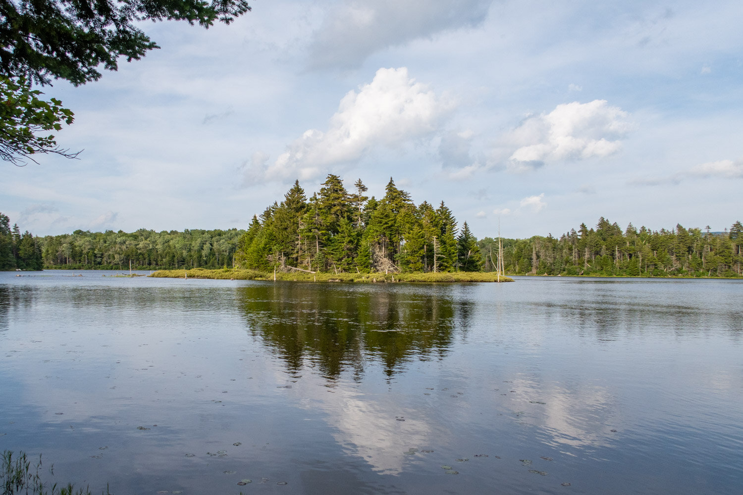
Bourn Pond is the more secluded of the two. It’s rich in beauty, with spruce trees surrounding it and two small islands in the middle.
Bourn Pond is also teeming with animal life. Occasionally you’ll see loons trying to catch fish, or you’ll hear them in the distance with their eerie call. In the area, you’ll also see plenty of moose footprints and poop, and if you’re lucky, maybe you’ll even see one forging in the water.
The other pond you’ll hike to is named Stratton Pond. It’s very picturesque, with Stratton Mountain towering over the large body of water.
On this route, you’ll get the chance to climb up to the summit of Stratton Mountain. On the top stands a fire tower offering incredible views of the Green Mountains. This fire tower is a historic landmark where James P. Taylor and Benton Mackaye envisioned creating the Long Trail and the Appalachian Trail.
By highlighting all these features of this route, hopefully, it motivates you to one day hike this trail. This comprehensive guide will help you plan for your backpacking adventure and allow you to get the most out of your trip.
Trail Facts
Length: 23.2 Miles
Duration: 2-3 Days
Elevation Gain: 4,200 Feet
Peak Elevation: 3,875 Feet
Best Season to Hike: Summer to Fall
Difficulty Level: Moderate
Bear Canisters: Not Required
Permits: $5 to camp around or stay at Stratton Pond shelter
Dogs: Allowed
Highlights
Bourn & Stratton Pond
Wildlife
Stratton Fire Tower
Prospect Rock Overlook
Dense Forests
Beautiful Camping Spots
Stratton pond bog bridge
Maps & Information
1510 National Geographic (Appalachian Trail, East Mountain to Hanover Vermont) Map: For finding your way, I recommend the National Geographic waterproof map. It will provide you with elevation profiles, mileage, shelter locations, and water sources.
Avenza App: For backpackers who prefer digital maps to navigate with, the Avenza app is excellent. It utilizes your mobile phone’s GPS to locate and track your position on a topographical map. It also provides all the same trail information as mentioned above with the paper map. You can purchase the digital 1510 Appalachian Trail, East Mountain to Hanover Vermont map through the app.
Parking & Trailheads
Parking can be found along Rootville Rd. (gravel) at a small parking area next to a water tower. You can only fit three, maybe four cars there. If it’s full, you can park along the side of the road. Rootville Rd. doesn’t get a lot of traffic, so your car should be fine.
To get to the parking area, follow these directions
When in Vermont take Route 7 to Manchester.
Look for signs to VT 30/11.
Turn onto VT 30/11, heading east.
Turn right onto East Manchester Rd.
At the 3-way stop sign, go straight onto Rootsville Rd.
Follow Rootsville for about a mile, and you’ll arrive at the parking area.
The trailhead kiosk is a couple of hundred feet uphill from the parking area on Old Rootville Rd., also known as Prospect Rock Trail. I have the exact parking and trailhead locations marked on the interactive map below.

Stratton mountain towering over stratton Pond
Terrain
The overall terrain on this loop is considered moderate. Most of the time, your gaining and losing small amounts of elevation throughout the trail. However, there are two exceptions to this. There's an initial 1,000-foot climb up Old Rootville Rd. (Prospect Rock Trail) and a 1,300-foot climb up Stratton Mountain.
Additionally, the terrain in springtime can become very muddy due to the increase in rainfall and snowmelt during that time of year. In certain areas, this can slow down your progress. The best thing to do is hold off hiking until June, and then the trail will have a chance to dry out more.
Dangers
The Bourn Pond - Stratton Pond Loop is considered a beginner-friendly backpacking route. However, there is one thing to be aware of when hiking this loop.
At mile 1.3 of the Lye Brook Trail, you'll come to a stream that's been severely impacted by beaver activity. During normal conditions, you can cross the creek by hopping from rock to rock or log to log. However, when a heavy rainstorm hits the area, the stream will flood, and crossing it will nearly be impossible.

prospect rock overlook
Bugs
Vermont is known for its bugs. In springtime, they’re the worst. Black flies and mosquitoes will hover around wet areas waiting for you to come by and eat you alive. However, when summer comes around, like mid to late July, they become less of a nuisance. Then, in the fall, they’ll be almost nonexistent.
To guard against these insects, I recommend using Picaridin Spray for any exposed skin and treat your clothing with Permethrin Spray. In addition, when the bugs are nasty, and bug spray doesn’t seem to be working, having a Head Net is almost a necessity.
Water Sources
Throughout this hiking loop, there’s an abundance of water sources in the form of streams, ponds, and springs only short distances apart. Because of this, you’re never too far away from a water source.
I have many of the water sources marked on the interactive map below so you can come up with a water carry plan for your hike. Make sure always to filter your water because giardia and bacteria are always a concern. One of the best water filters on the market is the Sawyer Squeeze because it’s lightweight and has a fast flow rate.

stratton fire tower

stratton fire tower view
Camping Spots & Shelters
Dispersed camping is allowed throughout this loop. Camping is only prohibited on top of Stratton Mountain since it’s a sub-alpine area.
Some of the best camping can be found at mile 6 of the loop along the secluded shores of Bourn Pond. As mentioned above, here, you’ll be surrounded by beautiful views of the pond and get a chance to see an abundance of wildlife like loons and moose.
There are three designated camping areas along Bourn Pond. The north tenting area, west tenting area, and south tenting area. Both the north and south tenting areas have composting privies.
The Green Mountain Nation Forest doesn’t have many restrictions regarding dispersed camping. However, here are the following camping practices that are recommended.
Camp at least 200 feet from the trail or body of water, including ponds and streams
Use only established campsites instead of making new ones
Do not camp in alpine or sub-alpine areas where trees are 8 feet or less so as not to harm the fragile ecosystems.
Use the privies when possible over digging a cathole
Practice Leave No Trace by carrying out all that you bring into the wilderness
Also, you have the option of staying in shelters on this loop. At mile 3, you’ll come to the William Douglas Shelter, a typical Appalachian Trail style lean-to that can accommodate up to 8 hikers.
Also located at mile 9 is the Stratton Pond Shelter. This shelter has bunk space for up to 16 hikers. In addition, there’s a covered porch area with benches and a picnic table. It costs $5 per person to stay the night and has a caretaker on-site to maintain the privy and shelter. Tent camping is permitted around the shelter.
Keep in mind; you can’t reserve shelters; they’re on a first-come basis.
All the campsites and shelters found throughout this loop are marked on the interactive map below to help you with your trip planning. For any additional information on backcountry camping, check out the Green Mountain Forest Service website.

bourn pond west tenting area
Which Direction Should You Hike?
It’s common to hike this loop in a counter-clockwise direction. I would have to agree with that preference. It allows for an easy low mile first day to camp when your pack is the heaviest. While still allowing for manageable days to follow.
Possible Trip Itinerary
3 Day Trip (counter-clockwise)
Day 1: (6 miles)
Start at the Prospect Rock trailhead.
Hike for 1.5 miles uphill on Old Rootville Rd., which is also called Prospect Rock Trail.
The trail ends at the junction with the Long Trail and the spur trail leading to the Prospect Rock Overlook. Keep your eyes open for a sign marking the spur trail; it’s easy to walk right past it.
After enjoying the view over Manchester, continue heading south on the Long Trail for 1 mile.
Here you’ll come to the junction with the Branch Pond Trail. At this point, you’re now entering the Lye Brook Wilderness.
Turn right onto Branch Pond Trail.
In 0.5 miles, you’ll come to the Williams Douglas Shelter.
Continue for another 3 miles and arrive at the Bourn Pond North campsite. You can camp here or go a little further and camp at two other designated areas.
Day 2: (9.7 miles)
Leave your campsite and hike for 0.3 miles on the Branch Pond Trail and come to the junction with the Lye Brook Trail.
Turn left onto the Lye Brook Trail.
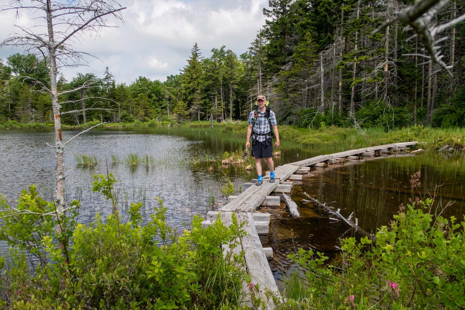
In 1.9 miles, you’ll come to Stratton Pond. Cross the outlet of the pond by way of a bog bridge.
Continue for another 0.6 miles and come to the junction with Stratton Pond Trail.
Turn left onto Stratton Pond Trail.
In 0.1 miles, come to the junction with the Long Trail.
Turn right onto the Long Trail and hike for 3.2 miles heading uphill to the Summit of Stratton Mountain.
There you can climb to the top of a fire tower and enjoy amazing views of the Green Mountains.
After soaking in all the views, retrace your steps back down from the mountain to where you came from. However, this time, continue past the Stratton Pond Trail for an additional 0.1 miles to Stratton Pond.
At Stratton Pond, cool off in the water and enjoy the beautiful scenery there. Then retrace your steps for 0.1 miles back to the Long Trail and Stratton Pond Trail junction.
Turn right onto Stratton Pond Trail, hike for 0.1 miles, and come to the junction with the shelter spur trail.
Continue straight, but now you’re on the shelter spur trail for 0.1 miles and arrive at the Stratton Pond Shelter. You can either stay at the shelter or tent camp in the general area for a $5 fee.
Day 3: (7.5 miles)
Leave the Stratton Pond shelter area via the spur trail.
In 0.1 miles, come to the junction with the Stratton Pond Trail.
Continue straight but now on the Stratton Pond Trail for 0.1 miles.
Here you’ll come to the junction with the Long Trail. Take a left onto the Long Trail for 0.1 miles back to Stratton Pond.
Pass by Stratton Pond and continue on the Long Trail for 5.7 miles.
Here you’ll come to the junction with Old Rootville Rd., which is also the Prospect Rock Trail.
The Long Trail will turn right sharply; however, you’ll continue straight on Old Rootville Rd. (Prospect Rock Trail)
In 1.5 miles, arrive back at your car.
