
Old Loggers Path Backpacking Guide
/
Rock Run stream
This article may contain affiliate links.
The Old Loggers Path (OLP) is a 27.8 mile loop hike located in the Loyalsock State Forest of Pennsylvania. This trail takes you back in time by having you follow a network of old logging roads and railroad grades. In fact, as you hike this trail in certain areas, you'll still see random piles of coal and the remnants of old machinery parts from when this land was logged.
Throughout this trail you’ll be able to enjoy many expansive views from Sprout Point Vista, Sharp Top Vista, Sullivan Mountain, and Rock Run Vista. In addition to those, one of the main highlights of the OLP is the picturesque Rock Run stream. It's labeled as the prettiest stream in Pennsylvania and it offers many swimming holes to cool you off on those hot summer days.
Trail Facts
Length: 27.8 Miles
Duration: 2-3 Days
Elevation Gain: 3,805 Feet
Peak Elevation: 2,204 Feet
Best Season to Hike: Spring to Fall
Difficulty Level: Moderate
Bear Canisters: Not Required
Permits: Not Required
Dogs: Allowed
Highlights
Spectacular Overlooks
Rock Run Stream
Historical Features
Swimming Holes
Waterfalls
Beautiful Forest

Maps & Information
Old Loggers Path Guidebook: This book is a must-have when planning for this hike. The guidebook breaks down in great detail what you will encounter on the trail in the form of trail notes so you can prepare accordingly. It contains information like mileage points, terrain description, possible campsite locations, water sources, and overlooks.
Backpacking Pennsylvania: 37 Great Hikes: This guidebook is a great resource for familiarizing yourself with all the different backpacking trails in PA. It provides information on the terrain, degree of difficulty, maps, and features you’ll enjoy along the trail.
AllTrails App: For backpackers who prefer digital maps to navigate with, the AllTrails app is great. It uses your mobile phone’s GPS to track your position on the route. You’ll find the Old Loggers Path there, along with over 400,000 other trails. The app provides you with elevation profiles, mileage, campsites, water sources, and points of interest.
Parking & Trailheads
Parking can be found in the old ghost town of Masten. The lot is at the intersection of Masten Rd and Pleasant Stream Rd. Since there is no cell service there, you may need to download an offline map on whatever navigation app you use on your phone. Or if you use a GPS unit, you’ll have to find a nearby address to get in the vicinity. The parking lot has many spaces to park your car and even bathrooms are available.
Either trailhead to the OLP can be walked to. One is right next to the parking lot and one is down Pleasant Stream Rd. If you're doing this trail in a counter-clockwise direction you’ll want the trailhead next to the parking lot. If you're doing the trail clockwise (which I recommend), you'll have to head uphill from the parking lot back to Pleasant Stream Road and turn right and cross over the bridge. You’ll then pass by some hunting cabins and in about 0.17 miles come to the trailhead on the right side of the road.
See the interactive map below for the exact parking and trailhead locations.

Sharp top vista
Terrain
Since the OLP follows a bunch of old railroad grades and logging roads it's a fairly easy trail to hike. There are mostly flat sections throughout and when the trail does decide to increase or decrease in elevation, you're only talking about 700 feet max and often times even less than that.
Dangers
The OLP is a very safe hike even for beginner backpackers, however there are a couple of things to be aware of and plan for.
One thing is that there's a healthy population of rattlesnakes in the area, especially on top of Sullivan Mountain at the rock outcroppings. Thankfully you don’t have to be too scared about one biting you on the trail because most of the time they give you plenty of warning before you’re too close. Just be mindful of your surroundings and make sure to listen for that rattle.
Another thing to be aware of is crossing Pleasant Stream at mile 10.38. If it has rained a lot over several days, the stream can become hazardous due to high water and a fast current. However, most of the time you'll find the water level only up to your ankle or mid-calf.

sullivan mountain overlook
Bugs
Springtime is when bugs are the worst on the OLP, especially if it has rained a lot. However, when summer comes around bugs will start to become less of a nuisance with bugs being mainly a problem around water sources. In autumn bugs will almost be no problem at all.
To protect yourself from mosquitoes and ticks use a combination of Permethrin Spray on your clothing and Picaridin Spray on any exposed skin.
Water Sources
There are many potential water sources throughout the OLP. However, some of them are seasonal streams that can dry up if it hasn't rained in a while. So, make sure when planning for this hike that you don't depend on one specific water source to fill up at. It could be dried up and lead you to hike without water till you reach the next water source.
There are two streams that are dependable and will be flowing even in dry conditions. They're Pleasant Stream and Rock Run.
I have all the water sources marked on the interactive map below to help you come up with a strategic water plan.
Don't forget to filter your water. Protozoa and bacteria are a concern. I recommend the Sawyer Squeeze Filter. It's lightweight, affordable, and has a fast flow rate.

rock run vista
Camping Spots & Shelters
Dispersed camping is allowed throughout the OLP with camping only prohibited on top of Sharp Top Vista. Hikers don't need a permit to camp as long as they don't intend to stay more then one night at a certain spot.
Some of the best campsites can be found at mile 21.33. If you cross over the top of Yellow Dog Falls at the confluence of Yellow Dog Run and Rock Run and follow Rock Run down stream, you'll find 3 exceptional campsites.
Also, there are two Adirondack style shelters along the trail that can fit between 6-8 hikers. They can be found at mile 4.83 and 17.52. Water can’t be found near the first shelter at mile 4.83. You’ll have to carry extra water for camp if you want to stay at this one. The added benefit is you’ll be really close to the view at Sprout Point Vista. Keep in mind these shelters can't be reserved. They're on a first-come basis.
I have all the campsites and shelters found throughout this trail marked on the interactive make below to help with your trip planning.
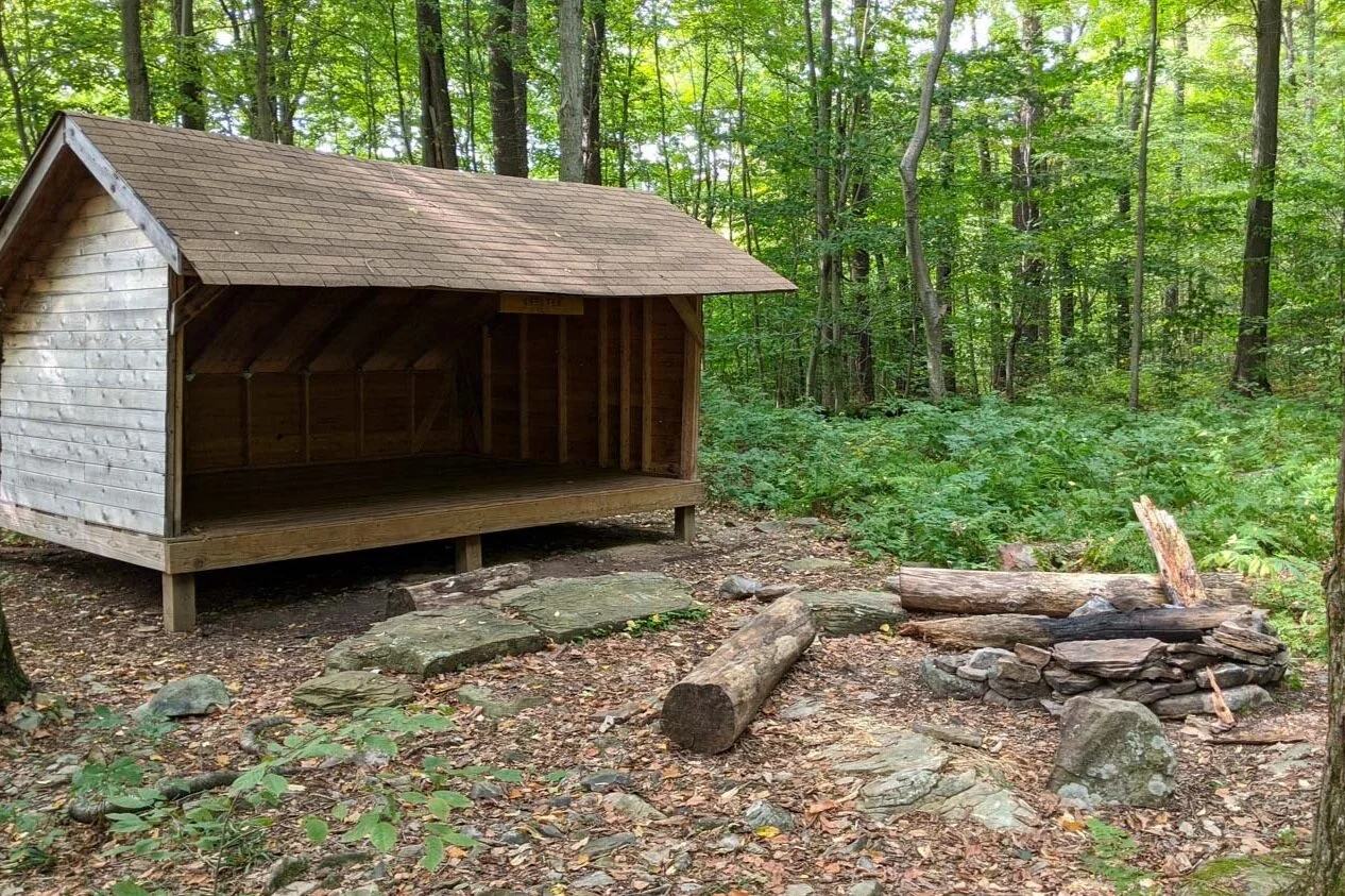
sprout point shelter

campsite along rock run stream
Which Direction to Hike?
It's common to hike the Old Loggers Path in a counter clockwise direction, however I recommend to do this trail in a clockwise fashion. This is so you can leave the best the trail has to offer for last with the scenic Rock Run area. Instilling a lasting impression.
Possible Trip Itineraries
3 Day Trip Option
Day 1:
Start at the trailhead on the east side of Pleasant Stream Road (Check map below for exact location)
Hike for 10.38 miles
Camp along Pleasant Stream
Day 2:
Hike for 10.95 miles
Camp along beautiful Rock Run Stream
Day 3:
Hike for 6.51 miles
Arrive at trailhead on the west side of Pleasant Stream Road, which is next to the parking lot
2 Day Trip Option
Day 1:
Start at the trailhead on the east side of Pleasant Stream Road (Check map below for exact location)
Hike for 13.40 miles
Camp near the top of Sullivan Mountain (dry campsite)
Day 2:
Hike for 14.40 miles
Arrive at trailhead on the west side of Pleasant Stream Road, which is next to the parking lot

Click Here
to open an Caltopo interactive map
Related Articles
Loyalsock Trail Backpacking Guide
The Loyalscok Trail is a 59.2-mile point-to-point hiking trail located in north-central Pennsylvania. On a backpacking trip in this region, you’ll experience diverse scenery, with many spectacular mountaintop views, cascading waterfalls, babbling brooks, hemlock forests, and deep gorges.
West Rim Trail (PA Grand Canyon) Backpacking Guide
This is a 30.5-mile point-to-point hike that skirts the edge of the Pine Creek Gorge, also known as the Grand Canyon of Pennsylvania. The trail offers many dramatic views of the canyon, different forest types of hemlocks, and American hardwood trees and has an abundance of wildlife.