
Allegheny Front Trail Backpacking Guide
/
This article may contain affiliate links.
The Allegheny Front Trail is a 42-mile hike located in the Moshannon State Forest of Pennsylvania. It utilizes a network of hiking trails, old logging roads, state forest roads, and Native American Indian paths to form a loop.
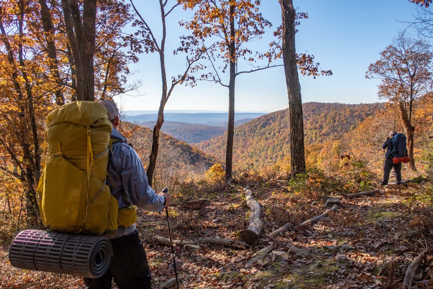
You'll get to experience six incredible vistas, mainly in the southeast and northeast sections of the trail. Also, you'll traverse through a variety of habitats – steep hillsides and valleys, wetlands, diverse forest types, rhododendron thickets, and mountain streams.
The Allegheny Front Trail is rich in history, with the Seneca American Indian tribe calling this place home at one time due to it being good for hunting and fishing.
Later European settlers moved in and cleared some of the land for farming, and after that, lumber companies moved in and clear-cut the forest for its vast stands of old-growth trees. However, the Moshannon State Forest eventually rose from the ashes through conservation efforts, and today it's once again a thriving forest.
Trail Facts
Length: 42 Miles
Trail Blazes: Yellow
Duration: 3-4 Days
Elevation Gain: 5,272 Feet
Peak Elevation: 2,403 Feet
Best Season to Hike: Spring to Fall
Difficulty Level: Moderate
Bear Canisters: Not Required
Permits: Not Required
Dogs: Allowed
Highlights
Amazing Mountain Views
Beautiful Streams
Diverse Forest Types
Boardwalks
Rhododendron Tunnels
Solitude

Allegheny Front Trail Maps & Information
Allegheny Front Trail Guidebook: This book is a must-have when planning for this hike. The guidebook breaks down in great detail what you will encounter on the trail in the form of trail notes so you can prepare accordingly. It contains information like mileage points, terrain description, possible campsite locations, water sources, and overlooks.
Backpacking Pennsylvania: 37 Great Hikes: This guidebook is a great resource for familiarizing yourself with all the different backpacking trails in PA. It provides information on the terrain, degree of difficulty, maps, and features you’ll enjoy along the trail.
AllTrails App: For backpackers who prefer digital maps to navigate with, the AllTrails app is great. It uses your mobile phone’s GPS to track your position on the route. You’ll find the Allegheny Front Trail there, along with over 400,000 other trails. The app provides you with elevation profiles, mileage, campsites, water sources, and points of interest.
Where is Parking for the Allegheny Front Trail?
The Allegheny Front Trail has many areas where you can park your car and access the trail. I have several of them marked on the interactive map below. You'll see that it's easier to find parking in the southern sections of the loop rather than in the more remote northern sections.
The trailheads and parking lots I recommend using are off Rattlesnake Pike. (PA Rte. 504) You'll find a parking lot located on the Westside and Eastside of the loop. They're the easiest to get to without having to drive down rough gravel State Forest Roads.

How Difficult is the Allegheny Front Trail’s Terrain?
The Allegheny Front Trail overall has moderate terrain. There are large sections of the trail that are relatively flat with only minor elevation changes. However, with that being said, every route has its challenges. Here are three trail conditions that could prove to be difficult.
Steep Climbs
There are a few sections of the trail that are steep. They’re located in the northwest section of the loop along Moshannon Creek and in the southeast section, where most of the views are. However, you’ll notice that the steep climbs are often short, only 500-700 feet in elevation gain.
Rocky
The trail can be rocky at times. When I finished this loop, my feet were definitely sore afterward. So, good shoes are a must. I recommend the Altra Lone Peak 9s. They have a rock plate built into their sole, which helps a lot in protecting your feet.
Muddy and Wet
Even though there are some boardwalks and footbridges throughout this trail, there are still many boggy and muddy areas where your feet will get wet. This is especially true in the southern sections inside the Black Moshannon State Park.
There are also many small streams without bridges where you’ll have to hop from rock to rock, and you’ll inevitably get your feet wet at some point on the trail.
What Kinds of Dangers do I Need to be Aware of on this Trail?
Moshannon Creek
One thing to be aware of is the water quality of Moshannon Creek. (known locally as the "Red Mo") Its located in the northwest section of the Allegheny Front Trail loop. This creek has an orange discoloration to it because of acid runoff from old coal mines in the area. Due to this pollution, the river is devoid of all aquatic life and is not safe to drink.
So, if you're planning to camp in this area, avoid getting water from this creek. Even if you boil or filter your water, it's still not safe to drink. Instead, source your water from the streams that spill into Moshannon Creek.
Rattlesnakes
Another thing to be aware of on this trail is rattlesnakes. There's a healthy population of them in the area. Keep in mind, though, that it's rare for someone to get bitten by one. Most of the time, they give you plenty of warning with their rattle before you're too close.
They tend to favor rocky, forested hillsides that are exposed to sunlight. So, when you're out there, be mindful of your surroundings and listen for that rattle.

How Bad are Bugs on the Allegheny Front Trail?
In late spring and summer, mosquitoes and other flying insects can be a real nuisance. But, of course, the bugs are not bad every year. A lot depends on how mild the winter was and how much rain there's been leading up to your hike. The best time to go and avoid these bugs would be fall.
Ticks are also a concern in this region since Pennsylvania is the tick capital of North America. All the grassy meadows you have to walk through on this trail don't help matters either since they're prime habitats for ticks.
However, don't be too worried about the bugs. As long as you take the proper precautions, you should be fine. To protect yourself from both ticks and mosquitoes, use a combination of Permethrin Spray on your clothing and Picaridin Spray on any exposed skin.
For additional precautions, you can take, check out my article on How to protect yourself from ticks and mosquitoes when hiking.
Where are the Water Sources on the Allegheny Front Trail?
When hiking the Allegheny Front Trail, you'll find that the footpath almost always follows a stream. So finding water is never an issue, even in drought conditions. However, no matter what the conditions are, I always recommend you have a solid water carry plan, so I have many of the water sources marked on the interactive map below to help you out.
Note: As was mentioned above, don't drink water from the polluted Moshannon Creek. Not to be confused with Black Moshannon Creek, which is acceptable to drink.
Also, make sure always to filter your water because giardia and bacteria are always a concern. One of the best water filters on the market is the Sawyer Squeeze because it's lightweight and has a fast flow rate.
Where Can You Camp on the Allegheny Front Trail?
Before your backpacking trip, you'll definitely want to plan where you're going to camp each night. Unfortunately, there aren't as many good campsites on the Allegheny Front Trail compared to other backpacking trips I've been on.
Some sites lack level ground for a tent, a quality water source, or beautiful surroundings. However, that doesn't mean there aren't any good campsites.
One prime camping spot is found at mile 5.61. (if you're doing the loop in a clockwise direction from Rattlesnake Pike Trailhead on the east side of the loop) This beautiful camping area is nestled in a grove of hemlocks and red pines. The Smays Run flows through it, providing a reliable water source.
Another nice camping spot is found at mile 31.70. This campsite is along the Black Moshannon Creek in a grove of hemlocks.
Several more decent campsites are found throughout the loop, and I have them marked on the interactive map below to help you with your trip planning.
Note: Primitive camping is not permitted along the section of the Allegheny Front Trail within the Black Moshannon State Park boundaries.
The Moshannon State Forest land doesn't have many restrictions regarding dispersed camping. However, here are a few guidelines to consider.
All camping must be at least 100 feet from any water source.
All campsites must be at least 25 feet from the nearest edge of a trail. Where possible, the camp should be out-of-sight of the trail.
All field privies must be at least 200 feet from a water source. Please, bury human waste at least 6 inches below ground.
All trash from camping must be carried out. Pack it in – pack it out.
Use only preexisting stone fire rings. Don't make new ones.
Do you Need a Permit to Camp Along the Allegheny Front Trail?
You don't need a permit if you're staying no more than one night at any campsite. However, it's strongly recommended that anyone camping overnight fill out the trail registers found throughout the loop.
For any additional information on dispersed camping, check out the Moshannon Forest Service website.

Which Direction Should You Hike on the Allegheny Front Trail?
Hiking this loop in a counterclockwise direction is the best way to go if you want the elevation to be more gradual. However, it can be hard to break up the mileage for each day and find a good campsite.
That's why I actually recommend going clockwise. By doing this, it allows you to break up your mileage for each day more evenly, and you'll get to stay at the most coveted campsites on the trail.
Possible Trip Itineraries
4 Day Trip (clockwise)
Day 1:
Start at Rattlesnake Pike Trailhead on the east side of the loop. (Check map below for exact location)
Hike for 11.45 miles
Camp at a small site along a stream
Day 2:
Hike for 11.02 miles
Camp along Six Mile Run. You'll have to cross the stream in order to get to the campsite.
Day 3:
Hike for 9.23 miles
Camp along Black Moshannon Creek in a grove of hemlocks
Day 4:
Hike 10.05 miles
Arrive back at the trailhead off of Rattlesnake Pike
3 Day Trip (clockwise)
Day 1:
Start at Rattlesnake Pike Trailhead on the west side of the loop. (Check map below for exact location)
Hike 11.18 miles
Camp along Benner Run in an open area among thickets of rhododendrons
Day 2:
Hike 14.44 miles
Camp in a Grove of hemlocks and red pines along Smays Run
Day 3:
Hike 16.13 miles
Arrive back at the trailhead off of Rattlesnake Pike

Click Here
to open an interactive CalTopo map
Related Articles
Black Forest Trail Backpacking Guide
This trail is a challenging, 43-mile, loop located in Pennsylvania's Tiadaghton State Forest. It’s considered by many as the most prized hiking trail in Pennsylvania. On this loop, you can expect to see dramatic mountain views, cascading streams, and lots of wildlife.
West Rim Trail (PA Grand Canyon) Backpacking Guide
This is a 30.5-mile point-to-point hike that skirts the edge of the Pine Creek Gorge, also known as the Grand Canyon of Pennsylvania. The trail offers many dramatic views of the canyon, different forest types of hemlocks, and American hardwood trees, and has an abundance of wildlife.