
Black Forest Trail Backpacking Guide
/
view from hemlock mountain
This article may contain affiliate links.
The Black Forest Trail is a challenging, 43-mile loop hike located in Pennsylvania's Tiadaghton State Forest. It’s considered by many as the most prized hiking trail of the Pennsylvania Wilds. Virgin hemlock trees once grew so thick here that sunlight couldn’t reach the forest floor, hence the name “black” forest.
Now, many of those giant hemlock trees are gone because of past logging and forest fires. However, over time the forest has rejuvenated, and today the area now has a thick tree canopy mostly made up of hardwood trees.
On a backpacking trip to this region, you can expect to see many dramatic mountain views, cascading mountain streams, and an abundance of wildlife.
Trail Facts
Length: 43 Miles
Trail Blazes: Orange
Duration: 3-4 Days
Elevation Gain: 8,550 Feet
Peak Elevation: 2,145 Feet
Best Season to Hike: Late Spring to Fall
Difficulty Level: Strenuous
Bear Canisters: Not Required
Permits: Not Required
Dogs: Allowed
Highlights
Dense Forests
Wildlife
Expansive Vistas
Waterfalls
Fun Stream Crossings

Little morris run waterfall
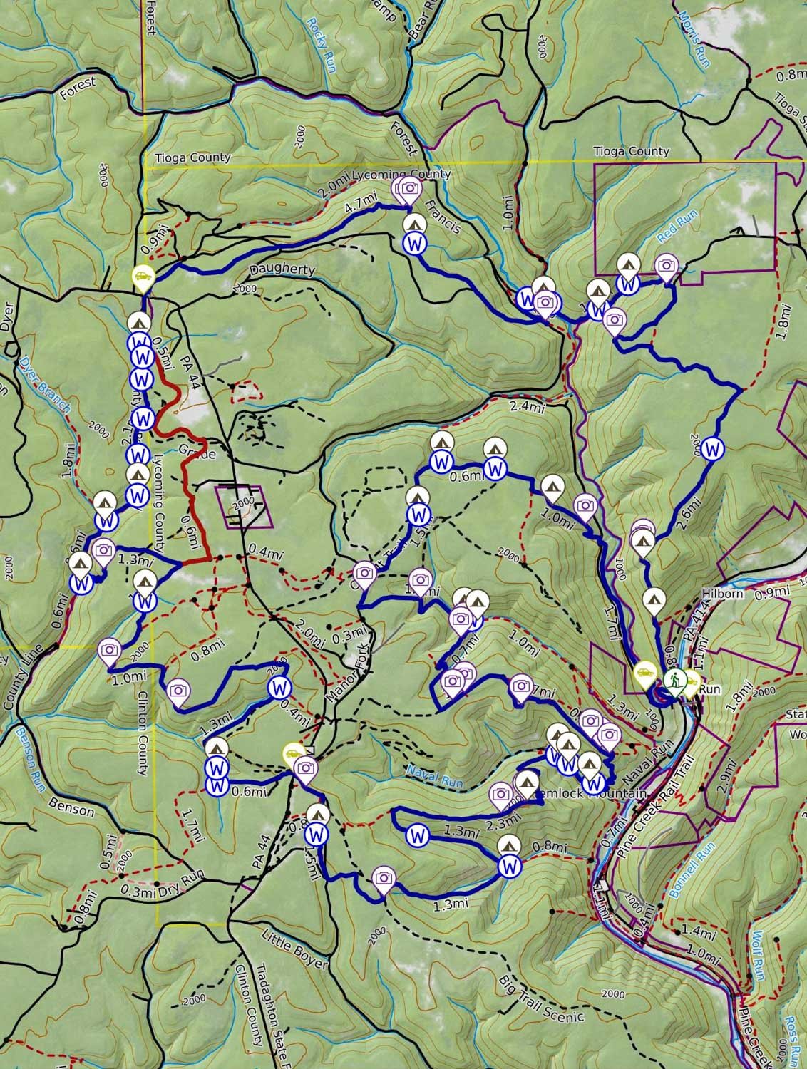
Black Forest Trail Maps & Information
The Black Forest Trail Guide Book & Map: This book is a must-have when planning for this hike. The guidebook breaks down in great detail what you will encounter on the trail in the form of trail notes so you can prepare accordingly. With the included topographical map, you will find that it contains mileage points, elevation profiles, possible campsite locations, water sources, and overlooks.
Backpacking Pennsylvania: 37 Great Hikes: This guidebook is a great resource for familiarizing yourself with all the different backpacking trails in PA. It provides information on the terrain, degree of difficulty, maps, and features you’ll enjoy along the trail.
AllTrails App: For backpackers who prefer digital maps to navigate with, the AllTrails app is great. It uses your mobile phone’s GPS to track your position on the route. You’ll find the Black Forest Trail there, along with over 400,000 other trails. The app provides you with elevation profiles, mileage, campsites, water sources, and points of interest.
Where is Parking for the Black Forest Trail?
There are several parking areas located throughout the trail. I have all of them labeled on the interactive map below. The parking area I recommend using is the one along Pine Creek in the town of Slate Run. As you turn off Route 414 and onto Slate Run Road, look for a sign that says Slate Run Recreational Parking. You should see it on your right before you cross the bridge over Pine Creek.
The other parking locations are in the woods, and there is the potential danger of porcupines chewing on your brake and fuel lines in this region. So I encourage you to avoid those parking areas.

rolling mountains on the black forest trail
How Difficult is the Black Forest Trail’s Terrain?
The Black Forest Trail has very challenging terrain with many steep climbs and knee-busting descents which will test your fitness level. Over the course of the hike, you will climb over 8,550 feet of cumulative elevation gain.
Another thing to be aware of is that a few sections of the trail can get a little rocky. One area, in particular, is when you come out of the County Line Branch drainage area at mile 16.5. Here you will have to do some rock scrambling. However, for the most part, you will encounter mainly dirt and small rocks on the trail.
Also, throughout the hike, you will have over 20 creek crossings, mostly found at the County Line Branch Stream. Your feet will get wet, and your progress will slow down in these areas. With your feet constantly getting wet, boots are not recommended on this trail. Instead, I suggest bringing lightweight, quick-drying trail runner shoes, like the Altra Lone Peak 9 shoes.
What Kinds of Dangers do I Need to be Aware of on this Trail?
The biggest danger for this hike would be the potential for flooding. If the area has been getting a lot of rain over several days, the creeks can swell up and make stream crossings very treacherous. In the event flooding occurs, there is a high water route where you can avoid most of the stream crossing on the trail. See the map below for the exact location.
Bears are another thing to be aware of in this region because there is a very large population of them. They would love nothing more than to steal your food. So, make sure to hang your food bag properly at night. If you’re not sure how to, check out my blog post How to Hang a Bear Bag the Right Way.
There is also a healthy population of rattlesnakes in this area. Without being too paranoid, make sure to watch the trail ahead of you and listen for that rattle.
In many of the mountain valleys along the trail grows a plant called stinging nettle. When you brush up against the leaves of this plant, just as the name implies, it will sting you and cause your skin to get red and inflamed.
Make sure to protect yourself from this plant by wearing pants or try your best to keep away from it physically.

Backpacking a section of the black Forest trail
How Bad are Bugs on the Black Forest Trail?
This area has an abundance of water, so mosquitoes are definitely around. When I hiked this trail, I got bitten up pretty good by them. Also, with this trail located in Pennsylvania and certain sections of it being quite bushy, ticks are a real concern.
To protect yourself from these bugs, make sure to use a combination of Picaridin Spray on any exposed skin and Permethrin Spray for your clothes.
To learn about additional precautions you can take to guard against these insects, check out my article on How to protect yourself from ticks and mosquitoes when hiking.
Where are the Water Sources on the Black Forest Trail?
Water is everywhere on this hike. You're almost always following a mountain stream. So you’re never going to be too far away from a water source. However, it’s always good to know where the water sources are when planning your trips, so I have all the water sources labeled on the interactive map below.
Make sure always to filter your water because giardia and bacteria are a concern. One of the best water filters on the market is the Sawyer Squeeze because it’s lightweight and has a fast flow rate.

view of pine creek valley
Where Can You Camp on the Black Forest Trail?
On the Black Forest Trail, there’s no shortage of campsites. You’ll never have to worry about finding a place to camp. However, some sites are much more remarkable than others.
Take, for instance, the campsite on top of Hemlock Mountain at mile 29.5. It sits at 2,000 feet and offers a breathtaking view of Pine Creek Gorge. The one drawback is that it’s a dry site, meaning there isn’t a water source up there. So, you will need to carry extra water with you when you camp there. A small price to pay in my mind for an incredible view.
Another area to consider camping is along the Callahan Run Stream. At around mile 27, you will see a waterfall and a couple of campsites right next to it. Nothing like the background noise of rushing water to put you to sleep
Other good campsites can be found along Little State Run Stream, along the Naval Run Stream, and at the end of the County Line Branch Stream. Refer to the interactive map below for all campsite locations.
The Tiadaghton State Forest has a few restrictions regarding primitive camping. Here are the following state forest regulations.
No permits are required to camp as long as you plan to stay only one night at each campsite.
While backpacking and camping in state forests and parks, please practice the Leave No Trace guidelines
All camping must be at least 200 feet from any stream or other open water source.
All campsites should be out of sight of the trail where possible.
For any additional information on primitive camping, check out the Tiadaghton State Forest website.

hemlock mountain camping spot
Which Direction Should You Hike on the Black Forest Trail?
Hiking this loop in a counterclockwise direction is the best way to go, in my opinion. For the first few miles, the forest isn’t as scenic as some other areas on the trail and so going counterclockwise allows you to get this section out of the way and into the nicer areas.
Also, by hiking the loop in this direction, you’ll be able to get the 17 creek crossings found at the County Line Branch Stream over with sooner.
Possible Trip Itineraries
4 Day Trip Option
Day 1:
Start at the main trailhead in Slate Run. (Check map below for exact location)
Hike for 8 miles
Camp along the Francis Branch Stream.
Day 2:
Hike for 10.5 miles
Camp along a stream at mile 18.3.
Day 3:
Hike for 12.7 miles
Camp along the Naval Run Stream at mile 31.
Day 4:
Hike for 12 miles
Arrive back at trailhead
3 Day Trip Option
Day 1:
Start at the main trailhead in Slate Run. (Check map below for exact location)
Hike for 16.5 miles
Camp along the County Line Stream
Day 2:
Hike for 13 miles
Camp on top of Hemlock Mountain at mile 29.7 (This is a dry site - bring extra water)
Day 3:
Hike for 13.5 miles
Arrive back at trailhead
Click Here
to open a CalTopo interactive map
Related Articles
West Rim Trail (PA Grand Canyon) Backpacking Guide
This is a 30.5-mile point-to-point hike that skirts the edge of the Pine Creek Gorge, also known as the Grand Canyon of Pennsylvania. The trail offers many dramatic views of the canyon, different forest types of hemlocks, and American hardwood trees, and has an abundance of wildlife.
Old Loggers Path Backpacking Guide
The Old Loggers Path is a 27.8-mile loop hike located in the Loyalsock State Forest of Pennsylvania. This trail takes you back in time by having you follow a network of old logging roads and railroad grades. Throughout this hike, you’ll be able to enjoy many expansive views and picturesque streams like Rock Run.