
Pemi Loop Backpacking Guide
/
This article may contain affiliate links.
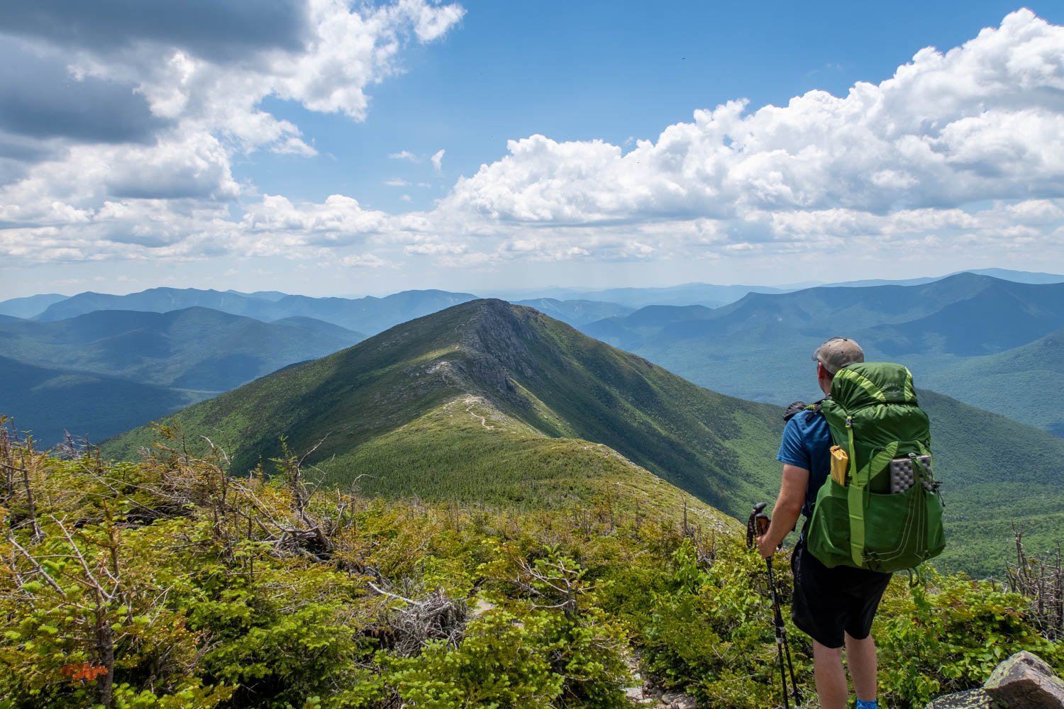
The Pemi Loop is a legendary 32-mile hike located in the White Mountains National Forest of New Hampshire. On this route, you'll enjoy long stretches of above-treeline hiking, including the Franconia Ridge Traverse and the Bonds Traverse.
Along the way, you'll knock out 8 of New Hampshire's 48 4,000-foot peaks, each offering a spectacular view of the Pemigewasset Wilderness.
The Pemi Loop is a challenging hike, with lots of rock scrambling and steep climbs, but you'll be rewarded with an adventure of a lifetime. Something you'll never forget for the rest of your life. In this article, I will help you plan for this backpacking trip so you can have the best time possible.
Trail Facts
Length: 32 Miles
Duration: 3-4 Days
Elevation Gain: 10,508 Feet
Peak Elevation: 5,249 Feet
Best Season to Hike: Spring to Fall
Difficulty Level: Extremely Strenuous
Bear Canisters: Not Required
Permits: Not Required
Dogs: Allowed
Highlights
Franconia Ridge
Bonds Traverse
Bondcliff
South Twin Mountain
Garfield Mountain

Maps & Information
740 National Geographic White Mountains (Franconia Notch, Lincoln) Map: For finding your way, I recommend the National Geographic waterproof map. It will provide you with elevation profiles, mileage, campsite/shelter locations, and water sources.
AllTrails App: This is a great hiking app for navigating this trail. It utilizes your mobile phone’s GPS to locate and track your position on a topographical map. It provides you with elevation profiles, mileage, and water sources, and points of interest. You can even create your own custom map.
Parking & Trailhead
The Lincoln Woods Trailhead is the traditional place where people usually park and begin their hike at. It's located off Route 112, just outside the town of Lincoln. It's a large parking area with many amenities, including restrooms. One downside is there's a fee to park here. It's $5/day (as of 2023). There's a parking kiosk with a wooden box where you deposit the money.
There's also a visitor center at the parking lot where you must register at. It's essential that you do this because if anything happens to you, then they'll be able to refer back to this and have a better idea of where you'll be to rescue you. If you have any questions, there's a forest ranger stationed there too.
Next to the visitor's center is also the trail kiosk. Just past that are wooden stairs that take you down to a large footbridge where you'll start your hike.
I have the exact parking and trailhead locations marked on the interactive map below.

Terrain
The terrain of the Pemi Loop can be classified as strenuous. With 10,508 feet of cumulative elevation gain, you’re going to endure a lot of steep and relentless climbs.
If your doing this loop counterclockwise, the most notable climb is 2,659 feet of elevation gain up to the summit of Bondcliff at 4,265 feet.
On the trail, you’ll encounter lots of rock scrambling that significantly slows down your progress. Whatever mileage per day you have done on trips prior, expect to cut that in half. The White Mountains are no joke. So when planning on how many miles you want to do in a day, take that into consideration.
With this rough terrain, good shoes are a must so your feet are protected. I recommend Altra Lone Peak 9 shoes. They have a rock plate built into their soles, which helps guard against sharp rocks.
Dangers
The most significant danger of this hike would be the rock scrambling. In particular, there's a section of trail going up to the summit of Garfield Mountain where a stream of water runs down the trail of boulders causing them to be slick. This is just one example of many sections you need to be very careful of and take your time. One slip could lead to serious injury.
Weather is another danger you need to be careful of. The White Mountains region is notorious for having bad storms occasionally pass through. With large sections of trail on exposed ridgelines, it's important to look ahead at the weather forecast. And I'm not talking weather.com, but actual summit forecasts like mountain-forecast.com, which gives you a forecast based on elevation. Also, weather.gov is an excellent resource for weather predictions.

Bugs
Springtime is bug season in the White Mountains. That means they're at their worst starting in May and going into June. You'll encounter black flies, gnats, mosquitoes, and ticks.
Keep in mind every year is different. Some years are worse than others. A lot depends on how mild the winter was and how much rain there's been leading up to your hike. The best time to backpack and avoid these bugs would be to go in July or later in the year.
Don't be too worried about the bugs. As long as you take the proper precautions, you should be fine. To protect yourself from these insects, use a combination of permethrin spray on your clothing and picaridin spray on any exposed skin.
For additional precautions, you can check out my article on how to protect yourself from ticks and mosquitoes when hiking.
Water Sources
On the Pemi Loop, you can expect water to be scarce. That's because most of the time, you're hiking up high on the Ridgeline. However, you'll find water sources to replenish your bottles at the backcountry huts and designated camping areas along the route. In the southern part of the loop at the lower elevation, you'll pass a few streams, but that's it.
I have many of the water sources labeled on the interactive map below. However, because of the long distance between water sources, you'll need to be strategic with a water carry plan. If you're unsure how to come up with one, check out my article on how much water you should carry backpacking.
Make sure to filter your water. Protozoa and bacteria are a concern. One of the best water filters on the market is the Sawyer Squeeze because it's lightweight, affordable, and has a fast flow rate.

Camping Spots & Shelters
With the Pemi Loop's terrain being very rough and rocky, you'll find that there aren't many areas suitable for backcountry camping. Because of this, the Appalachian Mountain Club has created three camping areas along the route.
If you're going in a counterclockwise direction on the loop, the Guyot campsite area will be the first one you reach at mile 11. Garfield Ridge campsite area is the next one at mile 17.1. Last but not least is the Liberty Springs campsite area at mile 24.6.
Most of the tent sites use wooden platforms to level out the ground. It can be tricky to pitch a tent on one of these. If you're unsure how to, check out my article on pitching a tent on a wooden platform.
Each camping area consists of several tent sites, a food prep area, a water source, and an outhouse. When you arrive at the camping area, a map will show you the general layout. The food prep areas have bear boxes to store your food during the night. Guyot and Garfield Ridge camping areas also have lean-to shelters as an option to stay overnight in.
As of 2023, there is a $15 per person caretaker fee to stay at these campsites. Also, they're on a first-come basis and can fill up fast, especially during peak season. If you don't want to pay the money or discover there are no more tent sites left, there are some areas where you can find stealth campsites. I have all the campsite locations marked on the interactive map below to help you plan your trip.
No permits are required to camp overnight in the White Mountains National Forest.
Another option for a place to stay overnight is at the Galehead Mountain Hut at mile 14.4. This would be a splurge because booking a stay at a hut in the White Mountains doesn't come cheap. However, you get to sleep in a comfortable bunk and get a delicious breakfast and dinner.
Click here for current prices to stay in a mountain hut.
Here are the following White Mountain National Forest-specific backcountry camping regulations.
Camping or fires are not allowed within 200 feet of trails and bodies of water.
Camping or fires are prohibited within 1/4 mile of backcountry facilities (shelters, huts).
Camping is restricted in alpine zones - where trees are 8 feet or less.
Group size is limited to no more than 10 people per party
Carry out what you carry in; bury human waste in a hole 4-8 inches deep, away from water, trails, and campsites.

Which Direction Should You Hike?
Hiking this loop in a counterclockwise direction is best if you want the elevation to be more gradual. Also, going this way allows you to climb up the more dangerous sections of the trail instead of going down them, making them safer.
Possible Trip Itineraries
3-Day Trip (counterclockwise)
Day 1: (11.2 miles)
Start at the Lincoln Woods trailhead.
0 miles: Cross the suspension bridge over the East Branch Pemigewasset River and turn right onto Lincoln Woods Trail.
2.9 miles: Reach the junction of the Franconia Falls Trail. Continue straight by crossing the bridge over Franconia Brook. The trail changes names and is now called Bondcliff Trail.
4.7 miles: The Bondcliff Trail turns left following the Black Brook, and this is where the long climb begins to the summit of Bondcliff.
8.8 miles: Scramble up a rock ledge called “Hillary’s Step.”
9.1 miles: Reach the Summit of Bondcliff.
10.3 miles: Reach the summit of Mount Bond.
10.8 miles: Reach the junction of the West Bond Spur Trail. This side trail is an optional 0.5-mile out and back hike to the West Bond Summit.
11 miles: Reach the junction of the Guyot Shelter Spur Trail. Turn right onto the spur trail.
11.2 miles: Reach the Guyot Camping Area. This is where you’ll camp for the night.
Day 2: (7.4 miles)
11.4 miles: Retrace your steps on the Guyot Shelter Spur Trail back to the junction of the Bondcliff Trail. Turn right onto the Bondcliff Trail.
11.8 miles: Reach the summit of Mount Guyot - South Peak.
12 miles: Reach the junction of the Twinway Trail. Turn left onto the Twinway Trail.
14 miles: Reach the summit of South Twin Mountain.
14.8 miles: After descending steeply from South Twin Mountain on the Twinway Trail, arrive at the Garfield Ridge Trail and Galehead Hut Spur Trail junction. Turn left onto the spur trail.
14.9 miles: Reach the Galehead Hut.
15 miles: After checking out Galehead Hut. Arrive back at the junction of Garfield Ridge Trail and Twinway Trail. Turn left onto Garfield Ridge Trail.
17.7 miles: Reach the junction of the Garfield Shelter Spur Trail. Continue straight on the Garfield Ridge Trail.
18.1 miles: Reach the summit of Garfield Mountain.
18.6 miles: Arrive at Garfield Pond. Look for a backcountry campsite to stay the night.
Day 3: (13.6)
21.6 miles: Continue on the Garfield Ridge Trail and reach the summit of Mount Lafayette. From here, continue straight on the Franconia Ridge Trail.
22.6 miles: Reach the summit of Mount Lincoln.
23.3 miles: Reach the summit of Little Haystack
25.2 miles: Reach the junction of the Liberty Springs Trail, where a camping area is located. Continue on the Franconia Ridge Trail.
25.5 miles: Reach the summit of Mount Liberty.
26.6 miles: Reach the summit of Mount Flume.
26.7 miles: Reach the junction of the Flume Slide Trail and Osseo Trail. Continue straight on the Osseo Trail. This is where you start the long descent back to the bottom of the valley.
30.8 miles: Reach the junction of Lincoln Woods Trail. Turn right onto the trail.
32.2 miles: Reach the suspension bridge over the East Branch Pemigewasset River. Turn left and cross the bridge and arrive back at the Lincoln Woods Trailhead.
4-Day Trip (counterclockwise)
Day 1: (7.4 miles)
Start at the Lincoln Woods trailhead.
0 miles: Cross the suspension bridge over the East Branch Pemigewasset River and turn right onto Lincoln Woods Trail.
2.9 miles: Reach the junction of the Franconia Falls Trail. Continue straight by crossing the bridge over Franconia Brook. The trail changes names and is now called Bondcliff Trail.
4.7 miles: The Bondcliff Trail turns left following the Black Brook, and this is where the long climb begins to the summit of Bondcliff.
7.4 miles: Reach a backcountry campsite along the Black Brook. This is where you’ll stay for the night.
Day 2: (10 miles)
8.8 miles: Continue on Bondcliff Trail and come to the rock ledge called “Hillary’s Step” that you’ll have to scramble up.
9.1 miles: Reach the Summit of Bondcliff.
10.3 miles: Reach the summit of Mount Bond.
10.8 miles: Reach the junction of the West Bond Spur Trail. This side trail is an optional 0.5-mile out and back hike to the West Bond Summit.
11 miles: Reach the junction of the Guyot Shelter Spur Trail.
11.4 miles: Reach the summit of Mount Guyot - South Peak.
11.6 miles: Reach the junction of the Twinway Trail. Turn left onto the Twinway Trail.
13.6 miles: Reach the summit of South Twin Mountain.
14.4 miles: After descending from South Twin Mountain on the Twinway Trail, arrive at Garfield Ridge Trail and Galehead Hut Spur Trail junction. Turn left onto the spur trail.
14.5 miles: Reach the Galehead Hut.
14.6 miles: After checking out Galehead Hut. Arrive back at the junction of Garfield Ridge Trail and Twinway Trail. Turn left onto Garfield Ridge Trail.
17.3 miles: Reach the junction of the Garfield Shelter Spur Trail. Turn right onto the spur trail.
17.4 miles: Arrive at the Garfield Shelter/Tent Area. This is where you’ll camp for the night.
Day 3: (7.8 miles)
17.5 miles: Retrace your steps on the Garfield Shelter Spur Trail back to the junction of the Garfield Ridge Trail. Turn right onto the Garfield Ridge Trail.
17.9 miles: Reach the summit of Garfield Mountain.
21.4 miles: Reach the summit of Mount Lafayette. From here, continue straight on the Franconia Ridge Trail.
22.4 miles: Reach the summit of Mount Lincoln.
23.1 miles: Reach the summit of Little Haystack
25 miles: Reach the junction of the Liberty Springs Trail, where a camping area is located. Turn right onto Liberty Springs Trail.
25.2 miles: Arrive at the Liberty Springs Tent Area. This is where you’ll camp for the night.
Day 4: (7.2 miles)
25.4 miles: Retrace your steps on the Liberty Springs Trail back to the junction of the Franconia Ridge Trail. Turn right onto the Franconia Ridge Trail.
25.7 miles: Reach the summit of Mount Liberty.
26.8 miles: Reach the summit of Mount Flume.
26.9 miles: Reach the junction of the Flume Slide Trail and Osseo Trail. Continue straight on the Osseo Trail. This is where you start the long descent back to the bottom of the valley.
31 miles: Reach the junction of Lincoln Woods Trail. Turn right onto the trail.
32.4 miles: Reach the suspension bridge over the East Branch Pemigewasset River. Turn left and cross the bridge and arrive back at the Lincoln Woods Trailhead.

Click Here
to open an interactive CalTopo map
Related Articles
A Guide to Backpacking Hut to Hut in the White Mountains
Backpacking in the White Mountains from the Franconia Range all the way through to the Presidential Range offers some of the most breathtaking scenery in the area. While hiking here, you will encounter steep and rugged mountains. However, you can treat yourself and enjoy the comfort of cabin-like huts to stay in along the way.
Bourn Pond - Stratton Pond Loop Backpacking Guide
This loop is located in Vermont’s Lye Brook Wilderness of the Green Mountain National Forest. You'll hike around two remote and picturesque ponds. Also, you’ll be able to climb up Stratton Mountain and enjoy spectacular views from the fire tower on the summit.