
Best Backpacking Trails in Pennsylvania
/
Lower alpine vista
Pennsylvania is often overlooked as a backpacking destination by many outdoor enthusiasts. Most people generally think of just hiking the 230 miles of the Appalachian Trail that runs through the state.
However, even though that trail is certainly great, some of the most scenic and rewarding backpacking trails lie within the vast 2.2 million acres of State Forestland found throughout Pennsylvania. This state is home to diverse landscapes, tranquil streams, and breathtaking views that invite exploration.
Here is a curated list of some of the best backpacking trails in Pennsylvania that you won’t want to miss out on.
1. Black Forest Trail

Hemlock Mountain
Trail Facts
Distance: 43 Miles
Difficulty Level: Strenuous
Elevation Gain: 8,550 Feet
Duration: 3-4 Days
About this Hike
The Black Forest Trail is a 43-mile loop hike located in Pennsylvania's Tiadaghton State Forest. It is the crown jewel of the Pennsylvania Wilds. Hemlock trees once grew so thick here that sunlight couldn’t reach the forest floor, hence the name “black” forest. Many of those giant hemlock trees are gone because of past logging.
However, over time, the forest has rejuvenated, and today, the area has a thick tree canopy mostly made up of hardwood trees. On a backpacking trip to this region, you can expect to see dramatic mountain views, cascading mountain streams, and abundant wildlife.
Black Forest Trail Maps & Guides
Black Forest Trail Guide: Our complete guide to backpacking the Black Forest Trail.
The Black Forest Trail Guide Book & Map: This guidebook breaks down what you will encounter on the trail in the form of trail notes. The included topographical map contains mileage points, elevation profiles, possible campsite locations, water sources, and overlooks.
AllTrails Digital Map: This app allows you to navigate the trail with your mobile phone and provides you with elevation profiles, mileage, campsites, water sources, and points of interest.
2. Loyalsock Trail

smith’s knob vista
Trail Facts
Distance: 59.2 miles
Difficulty Level: Strenuous
Elevation Gain: 11,919 Feet
Duration: 4-5 days
About this Hike
The Loyalsock Trail is a 59.2-mile point-to-point hiking trail located in north-central Pennsylvania. It’s considered one of the most beautiful yet rugged backpacking trails in Pennsylvania. Much of the trail follows old logging roads and abandoned railroad grades, and one section even follows the Towanda Path, once used by Native Americans.
On a backpacking trip in this region, you can expect to hike through diverse scenery, with many spectacular mountaintop views, cascading waterfalls, babbling brooks, hemlock forests, deep gorges, and a picturesque pond.
Loyalsock Trail Maps & Guides
Loyalsock Trail Guide: Our complete guide to backpacking the Loyalsock Trail.
Loyalsock Trail Guide Book & Map: This guidebook breaks down what you will encounter on the trail in the form of trail notes. The included topographical map contains mileage points, elevation profiles, possible campsite locations, water sources, and overlooks.
AllTrails Digital Map: This app allows you to navigate the trail with your mobile phone and provides elevation profiles, mileage, campsites, water sources, and points of interest.
3. West Rim Trail

Barbour rock overlook
Trail Facts
Distance: 30.5 Miles
Difficulty Level: Moderate
Elevation Gain: 5,648 Feet
Duration: 2-3 Days
About this Hike
The West Rim Trail is a 30.5-mile point-to-point hiking trail that skirts the edge of the Pine Creek Gorge, also referred to as the Pennsylvania Grand Canyon. It’s located in north central Pennsylvania inside the Tioga State Forest.
The trail offers many dramatic views of the canyon with its steep 1,000-foot walls. Also, throughout the trail, you’ll enjoy a variety of forest types that contain an abundance of wildlife.
West Rim Trail Maps & Guides
West Rim Trail Guide: Our complete guide to backpacking the West Rim Trail.
West Rim Trail Guide Book & Map: This guidebook breaks down what you will encounter on the trail in the form of trail notes. The included topographical map contains mileage points, elevation profiles, possible campsite locations, water sources, and overlooks.
AllTrails Digital Map: This app allows you to navigate the trail with your mobile phone and provides elevation profiles, mileage, campsites, water sources, and points of interest.
4. Laurel Highlands Hiking Trail

Laurel highlands shelter
Trail Facts
Distance: 70.1 Miles
Difficulty Level: Strenuous
Elevation Gain: 8,652 Feet
Duration: 4-6 Days
About this Hike
The Laurel Highlands Hiking Trail is a 70.1-mile point-to-point trail in southwestern Pennsylvania. It begins at Ohiopyle State Park, heads northeast, and ends at Conemaugh Gorge near Johnstown.
The trail travels up high along Laurel Ridge, which provides many vistas overlooking the nearby valleys. You’ll also hike through a beautiful forest with several areas where the trail mazes through large rock outcroppings.
Laurel Highlands Hiking Trail Maps
Laurel Highlands Hiking Trail Map: To navigate yourself around the wilderness area, I suggest using the map from the Pennsylvania State Forest Service. It provides detailed information, such as elevation profiles, points of interest, mileage, shelter locations, and water sources.
AllTrails Digital Map: This app allows you to navigate the trail with your mobile phone and provides elevation profiles, mileage, campsites, water sources, and points of interest.
5. Old Loggers Path
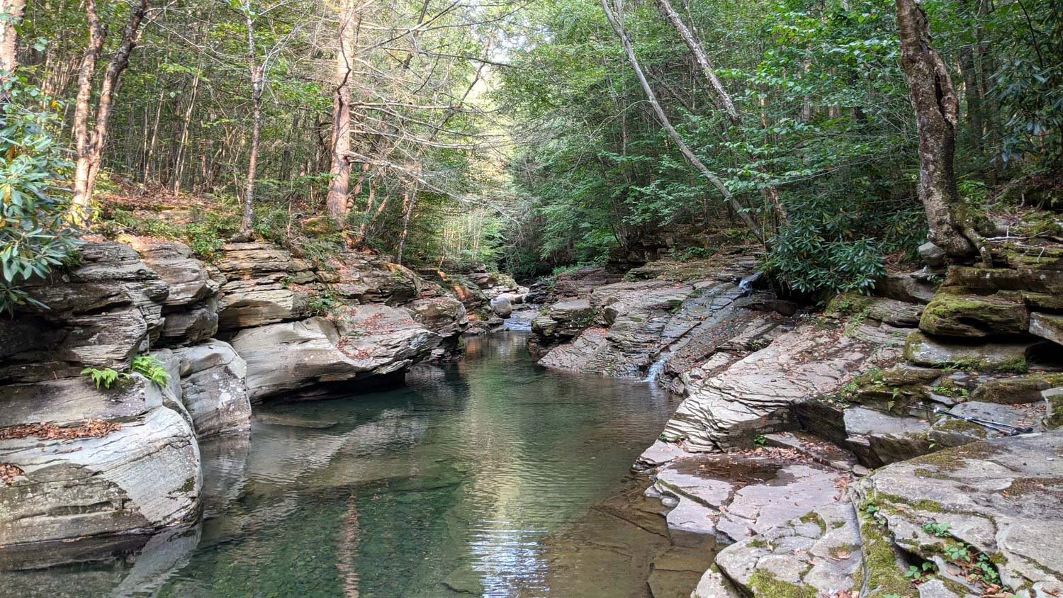
Rock Run along old loggers path
Trail Facts
Distance: 27.8 Miles
Difficulty Level: Moderate
Elevation Gain: 3,805 Feet
Duration: 2-3 Days
About this Hike
The Old Loggers Path is a 27.8-mile loop hike located in the Loyalsock State Forest of Pennsylvania. This trail takes you back in time by having you follow a network of old logging roads and railroad grades. In fact, as you hike this trail in certain areas, you'll still see random piles of coal and the remnants of old machinery parts from when this land was logged.
Throughout this trail, you’ll be able to enjoy many expansive views from Sprout Point Vista, Sharp Top Vista, Sullivan Mountain, and Rock Run Vista. In addition, one of the trail’s main highlights is the picturesque Rock Run stream. It's labeled as the prettiest stream in Pennsylvania.
Old Loggers Path Maps & Guides
Old Loggers Path Guide: Our complete guide to backpacking the Old Loggers Path.
Loyalsock Purple Lizard Topographical Map: To navigate yourself around the wilderness area, I suggest using the waterproof map from Purple Lizard. It provides detailed information, such as elevation profiles, points of interest, mileage, and water sources.
AllTrails Digital Map: This app allows you to navigate the trail with your mobile phone and provides elevation profiles, mileage, campsites, water sources, and points of interest.
Conclusion
As you can see, Pennsylvania has so much to offer when it comes to backpacking. These are only a few of the 37 backpacking trails in Pennsylvania. For a complete list of backpacking trails in the state, check out the book Backpacking Pennsylvania: 37 Great Hikes.