West Rim Trail (PA Grand Canyon) Backpacking Guide
/
Barbour rock overlook
This article may contain affiliate links.
The West Rim Trail is a 30.5 mile point to point hike that skirts the edge of the Pine Creek Gorge, also referred to as the Grand Canyon of Pennsylvania. It’s located in north central Pennsylvania inside the Tioga State Forest. The trail offers many dramatic views of the canyon with it’s steep 1,000 foot walls. Also, throughout the trail you’ll get to enjoy a variety of forest types that contain an abundance of wildlife. In this backpacking guide I will help you plan and prepare for your trip so you can get the most out of it.
Trail Facts
Length: 30.5 Miles
Duration: 2-3 Days
Elevation Gain: 5,648 Feet
Peak Elevation: 2,043 Feet
Best Season to Hike: Spring to Fall
Difficulty Level: Moderate to Strenuous
Bear Canisters: Not Required
Permits: Not Required
Dogs: Allowed
Highlights
Grand Canyon Views
Photo Ops
Beautiful Forests
Cascading Streams
Abundance of Wildlife

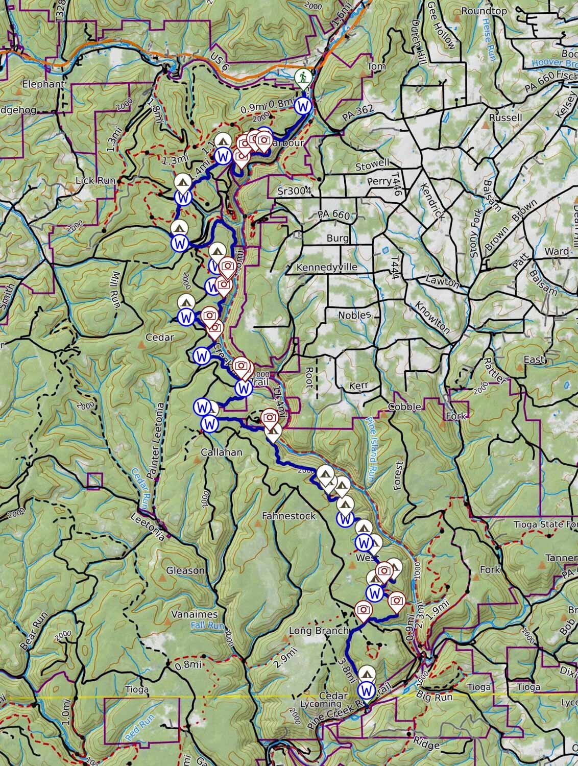
Maps & Information
The West Rim Trail Guide Book & Map: This book is a must-have when preparing for the hike. The guidebook breaks down in great detail what you will encounter on the trail in the form of trail notes. With the included topographical map you’ll find that it contains mileage points, elevation profiles, possible campsite locations, and areas with views.
AllTrails App: This is a great hiking app for navigating this trail. It utilizes your mobile phone’s GPS to locate and track your position on a topographical map. It provides you with elevation profiles, mileage, and water sources. You can even create your own custom map.
Parking & Shuttle
Parking can be found at the Rattlesnake Rock Access Area parking lot at the southern terminus of the trail along Rt. 414. Parking can also be found at the northern terminus in Ansonia along Colton Road. Both areas should have plenty of parking spaces for your car. See the interactive map below for the exact parking and trailhead locations.
Since this trail is a point-to-point hike, not a loop, there’s a shuttle service available by Pine Creek Outfitters. They have two shuttle options you can reserve ahead of time.
Option 1: You park your car at one end of the trail, and while you hike, they will move your car for you to the other end of the trail.
Option 2: They will pick you up at one of the parking lots of your choosing and drop you off at the other end of the trail and then you’ll just basically be hiking back to your car.

Old Dynamite shed, a remnant from the logging era
Food & Lodging
Burnin Barrel Bar: This place is located just past the northern terminus of the trail in Ansonia, perfect for a post hike meal. It serves typical bar food like burgers and wings. It also has a good selection of beers on tap.
Colton Point Motel: This motel is an affordable option to stay the night. Included in your stay is a delicious breakfast. It’s also located just a couple miles from the West Rim Trail in the Ansonia area.
Terrain
The first 2 miles of the West Rim Trail are the hardest (or last 2 miles, if you’re hiking southbound). You have a 1,000 foot climb up to the top of the canyon. Once there you can easily be deceived into thinking that the rest of the trail will be flat since you’re hiking the rim of the canyon. However, that’s far from accurate. What you’ll find out is that even though you’re following the rim of the canyon, the trail dips in and out of ravines that cause constant changes in elevation, which in turn increases the difficulty of this trail.

Dangers
Bears and rattlesnakes are a common site along this trail. With bears, they’re not a direct threat to you but mainly a threat to your food. So make sure you know how to hang a food bag properly. If you’re not sure how to, check out my blog post How to Hang a Bear Bag the Right Way. With rattlesnakes, make sure to watch the trail ahead of you and listen for that rattle. But, don’t be to scared about running into one on the trail. Most of the time they give you plenty of warning before you’re even close.
As the trail skirts the edge of the canyon there are steep drop offs at certain places that are dangerous. One false step could have you falling down hundreds of feet into the canyon. Extra care to your footing is needed in these areas.
In some sections of the trail grows a plant called stinging nettle. When you brush up against the leaves of this plant, just as the name implies, it will sting you and cause your skin to get red and inflamed. Make sure to protect yourself from this plant by wearing pants or trying your best to physically keep away from it.
Bugs
In early spring bugs can be a nuisance on the trail. However, as summer comes along the bugs tend to taper off. When I did this hike in the summer, I noticed some mosquitoes around the water sources but that was pretty much it.
Certain sections of this trail are slightly overgrown and other areas have tall grass you have to hike through, so ticks are a concern especially since you’re hiking in the tick capital of North America.
To protect yourself from mosquitoes and ticks use a combination of Permethrin Spray on your clothing and Picaridin Spray on any exposed skin.

stone and iron fence overlook
Water Sources
On the West Rim Trail there are definitely fewer water sources available in the southern half compared to the northern half and some of these water sources aren't reliable, especially in dryer conditions. So, make sure to carry a little extra water in case your planned fill-up spot is dried up and you have to hike to the next one.
I have all the water sources marked on the interactive map below to help you come up with a strategic water plan.
Don't forget to filter your water. Protozoa and bacteria are a concern. I recommend the Sawyer Squeeze Filter. It's lightweight, affordable, and has a fast flow rate.
Camping Spots
There’s no shortage of campsites on the West Rim Trail. However, some campsites are a lot better than others. If you’re doing a more relaxed trip of three days and going northbound, I recommend the campsites at mile 10.25 and mile 19.25. Both areas have you camping in beautiful hemlock forests. The spots are also flat and can accommodate multiple tents. The only downside is that they are not near water sources so you’ll have to carry extra water to them.
If you’re doing a two day northbound hike, I would recommend the campsites at mile 14.59 and mile 14.74 at the stone and iron fences. These two separate campsites both have incredible views of the Pine Creek Gorge as you can see in the picture below.
I have all the campsites found throughout this trail marked on the interactive make below to help with your trip planning.

stone and iron fence campsite
Which Direction to Hike?
Hiking northbound or southbound both work for this trail, however the preferred direction to go is northbound. There are two reasons for this. First, you get the most difficult part of the trail out of the way in the beginning with a 1000 foot climb to the top of the canyon. Second, going this way will let you end in a memorable way with the spectacular overlook at Barbour Rock.
Possible Trip Itineraries
3 Day Trip Option
Day 1:
Start at the southern terminus of the trailhead at Rattlesnake Rock Recreational Area (Check map below for exact location)
Hike for 10.25 miles
Camp in a nice hemlock forest (dry campsite)
Day 2:
Hike for 9 miles
Camp in another beautiful hemlock forest (dry campsite)
Day 3:
Hike for 11.21 miles
Arrive at northern terminus of the trail
2 Day Trip Option
Day 1:
Start at the southern terminus of the trailhead at Rattlesnake Rock Recreational Area (Check map below for exact location)
Hike for 14.59 miles
Camp at the stone and iron fence area
Day 2:
Hike for 15.87 miles
Arrive at the northern terminus of the trail
Click Here
to open an interactive CalTopo map
Related Articles
Black Forest Trail Backpacking Guide
This trail is a challenging, 43-mile, loop located in Pennsylvania's Tiadaghton State Forest. It’s considered by many as the most prized hiking trail in Pennsylvania. On this loop, you can expect to see dramatic mountain views, cascading streams, and lots of wildlife.
Old Loggers Path Backpacking Guide
The Old Loggers Path is a 27.8-mile loop hike located in the Loyalsock State Forest of Pennsylvania. This trail takes you back in time by having you follow a network of old logging roads and railroad grades. Throughout this hike, you’ll be able to enjoy many expansive views and picturesque streams like Rock Run.