
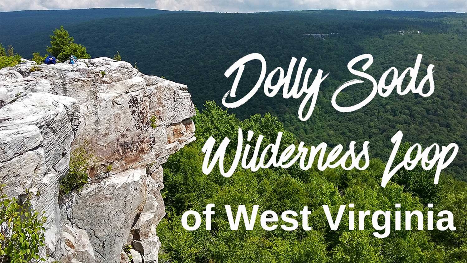
Dolly Sods Wilderness Loop Backpacking Guide
/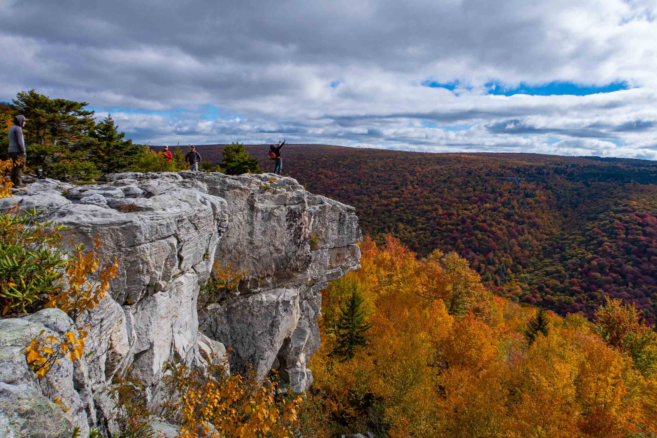
Dolly Sods Lion’s Head Overlook
This article may contain affiliate links.
The Dolly Sods Wilderness is located on top of the Allegheny Plateau of West Virginia and is part of the Monongahela National Forest.
A backpacking trip in this area will expose you to a very diverse and unique landscape with sphagnum bogs, grassy meadows lined by spruce trees, wind-carved boulders, and beautiful mountain vistas. If you haven’t hiked this amazing place yet, I suggest putting this one on your list.
History
The name Dolly Sods derives from an 18th-century German family named the Dahles, who settled nearby and used the open mountaintop meadows called “Sods” for grazing their sheep. Long after the Dahles moved on from this area, the locals Americanized the name by changing the spelling to “Dolly,” thus, this region became known as Dolly Sods.
Before the early settlers, this area was teeming with life. There were dense forests filled with massive red spruce and hemlock trees. Also, there was a healthy population of animals like elk, bears, foxes, deer, bobcats, and mountain lions.
Unfortunately, the Dolly Sods didn’t stay this way. In the late 19th and early 20th centuries, this place was decimated by heavy logging and forest fires. This left an almost destroyed ecosystem.
If that wasn’t enough, the military used this place for artillery and mortar training during World War II. Still today, at some trailheads, the Army Corp of Engineers displays signs warning hikers to stay on the trail because there may be unexploded ordnance in the area.
Thankfully, in the 1970s, The Nature Conservancy environmental organization stepped in and began purchasing the land to preserve it. Then, they donated it to the National Forest Service, and today it’s classified as a federally designated wilderness area. With the Dolly Sods now being protected, the region is once again flourishing.

Open meadow in the dolly sods wilderness
Trail Facts
Length: 26.08 Miles
Duration: 2-3 Days
Elevation Gain: 2613 Feet
Peak Elevation: 4170 Feet
Best Time to Visit: Spring to Fall
Difficulty Level: Moderate
Bear Canisters: Not Required
Permits: Not Required
Dogs: Allowed
Highlights
Sphagnum Bogs
Grassy Meadows
Amazing Mountain Views
Wind Carved Sandstone
Cascading Waterfalls
Water Crossings
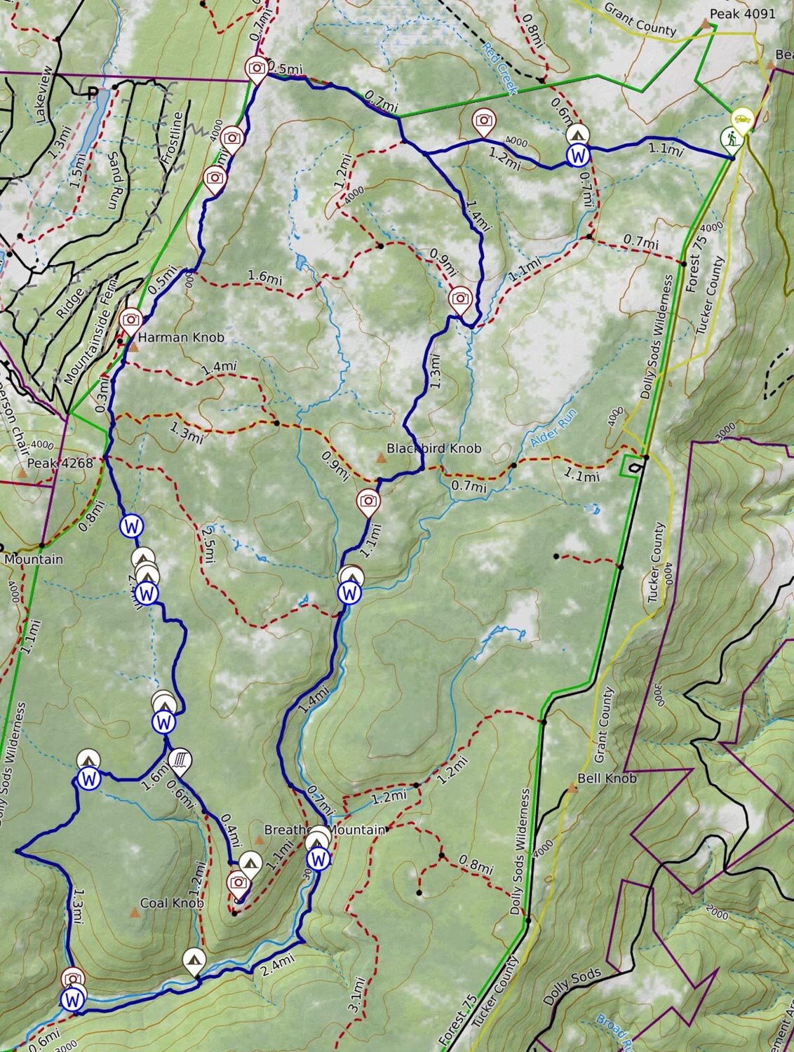
Maps & Information
Dolly Sods/Seneca Rocks Purple Lizard Topographical Map: To navigate yourself around the wilderness area, I suggest using the waterproof map from Purple Lizard. It provides detailed information, such as elevation profiles, points of interest, mileage, and water sources.
AllTrails App: The Dolly Sods Wilderness has no blazes, and there may not be signposts at certain intersections. Because of this, I also recommend using a GPS navigation app like AllTrails. The app provides you with elevation profiles, mileage, campsites, water sources, and points of interest.
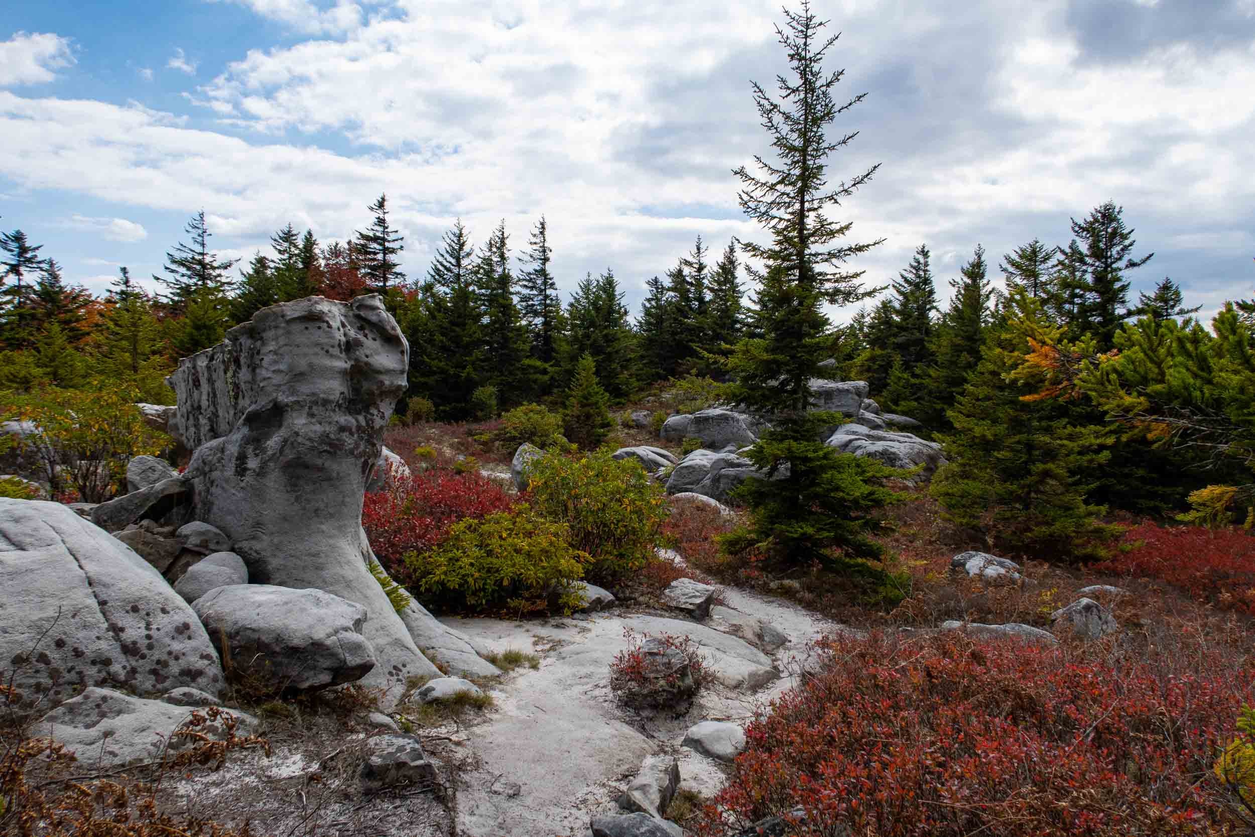
rocky terrain in dolly sods
Parking & Trailheads
To start this hike, you’ll use the Bear Rocks Trailhead. Access the trailhead and parking area by taking Forest Road 75, which is a rough gravel road. A wooden trail kiosk marks the Bear Rocks Trailhead, and you can find parking along the shoulder there.
The Dolly Sods is a popular hiking destination, and sometimes you’ll find many cars parked there already. However, if you drive up about 200 yards north of the trailhead, there is a huge parking area for overflow. See the map below for exact parking locations.
Terrain
With regards to steep climbs or difficult descents, there is really nothing to worry about when hiking this loop. There are only relatively minor elevation changes.
The real challenge comes with water. You have bogs in some areas of the northern Dolly Sods that are saturated with water. At times you will have to hop from rock to rock to try to keep your shoes from sinking deep in the mud. This will significantly slow down your pace.
Because of these trail conditions, I strongly encourage you to leave your hiking boots, which take forever to dry, at home and instead bring quick-drying trail runners like the Altra Lone Peak 9 Shoes.

Dangers
There is little to be concerned about on this hike. However, bears are active in the area. When I did this hike, I saw several bear prints on the trail. Therefore, you will want to make sure to store your food properly at night. If you're not sure how to, check out my article on how to hang a bear bag.
Also, there is some danger when you ford the creeks. For example, Red Creek has a fast current, and the water level can be high depending on how much it has rained in the days prior. When I did my hike, some areas of the creek were up to my mid-thigh. To be safe, check out my article on how to ford a river.
Bugs
With all the water in Dolly Sods, you would think that you'd have to worry about bugs, but surprisingly they are not a problem. This is probably because the region is consistently windy. However, it's always good to bring some bug spray just in case. I recommend using Picaridin for any exposed skin and Permethrin to spray on your clothing.

Water Sources
For the most part, water sources are very prevalent throughout this hike. However, there is one exception to this with the Raven Ridge and Rocky Ridge Trails. They sit on top of the Allegheny Plateau and have no water sources. So, make sure that you have plenty of water in these sections.
I have many of the water sources marked on the interactive map below to help you plan your trip. If you’re unsure how to develop a proper water plan, check out my article on how much water you should carry backpacking.
As always, make sure to filter your water because giardia and bacteria are a concern. One of the best water filters on the market is the Sawyer Squeeze because it’s lightweight and has a fast flow rate.
Camp Spots
Throughout the Dolly Sods Wilderness, you’ll find that there are many great campsites. You can find some of the best spots along Big Stonecoal Trail and at the area where the Left Fork Creek and Red Creek meet called “The Forks.” I have many of the campsites marked on the interactive map below.
The Monongahela National Forest doesn’t require a permit to camp overnight. However, here are the following camping practices that are strongly recommended.
Camp only at existing campsites. They usually have a fire ring, and there’s bare ground around them.
If you camp at a place without a fire ring, DO NOT create one. Use a backpacker-type stove for your cooking needs and enjoy a night without a campfire.
Practice “Leave No Trace” by carrying out all that you bring into the wilderness.
For any additional information on wilderness camping, check out the Monongahela National Forest Service website.

Dolly Sods Video
Trip Itinerary
Day 1: (9.24 miles)
Start at the Bear Rocks Trailhead off of Forest Road 75
Hike for 1.31 miles on the Bear Rocks Trail. Pass through a small boggy section that transitions to a boardwalk. After that, crossover the Red Creek where there is a nice campsite. Make sure to top your water off here; there won’t be any water sources for a while. Continue on for 1.09 miles through small wooded areas and an open meadow. The trail will end at the Raven Ridge Trail junction.
Turn right onto the Raven Ridge Trail and hike for 1.38 miles onto a grassy hilltop meadow that eventually enters into a red spruce forest. After a short while, the forest will end, and the landscape will open up and become rocky. Here you will arrive at the Rocky Ridge Trail junction.
Turn left onto the Rocky Ridge Trail for 3 miles and enjoy many spectacular views of the Canaan Valley and enjoy investigating many unique wind-carved boulders. It will be rocky on certain sections of this trail, and cairns are used to mark the way. This trail eventually intersects with Blackbird Knob Trail.
Take a right onto Blackbird Knob Trail for about .25 miles to a four-way trail junction of the Breathed Mountain Trail, Big Stonecoal Trail, and a forestry road that leads to Canaan Valley. At the intersection, there is a wooden trail kiosk with a map of the area.
Take the middle trail called Big Stonecoal that is slightly narrower than the others. The trail will descend into a thick forest. In about 2.21 miles, you will come to Stonecoal Run Creek. There will be several campsites that are along the creek. They are some of the best in Dolly Sods. Camp here for the night.
Day 2: (10.4 miles)
On this day, most of the time, you will be hiking in the forest. Start the day by hiking on Big Stonecoal Trail for about .16 miles following the Stonecoal Creek. You will cross this creek several times and, for a small section, enjoy a grand forest of mature pine trees. Eventually, you will come to the Dunkenbarger Trail junction, which you will want to take note of because eventually, you’re going to retrace your steps back to this trail junction.
Continue hiking on Big Stonecoal Trail for .56 miles. You will cross Stonecoal Creek again and pass a beautiful waterfall on your right. After that, you will come to the Rocky Point Trail junction.
Take the Rocky Point Trail for about .58 miles till you see a side trail marked by a rock cairn on your left. Follow that trail for .1 miles by rock scrambling uphill following more rock cairns. Soon you will reach a flat area where there will be views of Lions Head and mountain ranges. After exploring Lions Head retrace your steps on Rocky Point Trail and Big Stonecoal Trail until you come to the Dunkenbarger Trail junction.
Turn left onto the very muddy Dunkenbarger Trail for .8 miles. You will come upon the Dunkenbarger Run Creek. Cross the creek, and there is a great campsite right on the other side. Continue on for .9 miles to the Little Stonecoal Trail junction.
Turn left onto the Little Stonecoal Trail for 1.4 miles descending rapidly to the Red Creek. Ford the creek and continue on the trail till you come to the Red Creek Trail junction.
Take a left onto the Red Creek Trail for .91 miles and gradually climb in elevation. Then there will be a steep descent down to the creek, and you will arrive at the Big Stonecoal Trail junction. There is a nice camp spot along the stream here. Continue on the Red Creek Trail for 1.6 miles. You will experience more elevation changes till you eventually have to Ford the creek again. On both sides of the stream are great camping spots.
After fording the creek, you will start a decent climb out of the valley for .59 miles, reaching the Rocky Point Trail. Continue on the Red Creek Trail, and in a few hundred yards, the trail will level out on an old railroad bed. Follow the railroad bed for 1.38 miles and come to the area known as “The Forks.” Here you will find many camping spots along the creek. Ford the Left Fork Creek and find the best camping spots in the area. This is where you will spend the night.
Day 3: (6.4 miles)
Start the day by continuing on the Red Creek Trail for .91 miles hiking uphill out of the drainage area. After a little bit, the trail will start to change, and you will pass through a mix of dense forests and open meadows before arriving at the Blackbird Knob Trail junction.
Turn right onto the Blackbird Knob Trail and hike for a short .31 miles through bogs to the Upper Red Creek Trail junction.
Take a left on the Upper Red Creek Trail for 1.3 miles and enjoy a beautiful open grassy area leading to small thickets of trees. After leaving the thicket, it will open up again to a large meadow with great views. Then you will arrive at the Dobbin Grade Trail junction.
Turn right onto the Dobbin Grade Trail for .1 miles through several muddy areas, and you will come to the Raven Ridge Trail junction. (Don’t make the same mistake I made and continue on the Dobbing Grade Trail. It’s just a muddy mess that you will regret doing).
Turn left onto the very dry Raven Ridge Trail for 1.42 miles and hike uphill through more open meadows and wooded areas. Eventually, you will arrive back at the Bear Rocks Trail junction you passed on the 1st day.
Turn right onto the Bear Rocks Trail and retrace your earlier steps all the way to the trailhead for 2.4 miles.
Related Articles
Spruce Knob/Seneca Creek Loop Backpacking Guide
This hike is located in the Monongahela National Forest of West Virginia. Here you’ll get to see beautiful streams with waterfalls, mountain meadows, incredible views from the Spruce Knob tower, and explore an old plane wreck.
Cranberry Wilderness Loop Backpacking Guide
This loop is located in West Virginia's Monongahela National Forest. Here you’ll get to experience a variety of ecosystems such as Appalachian hardwood forests and red spruce woodlands over moss-covered ground. In addition, you'll follow a cascading stream.